Choose how to read
The full view retains the technical content, figures and sources. The plain-language explanation introduces the ideas without changing the findings.
Checking a water-storage solver
What this study checks
This dashboard compares ways of solving the same assumed water-storage equation. It does not rate flood-warning accuracy.
How the settings were chosen
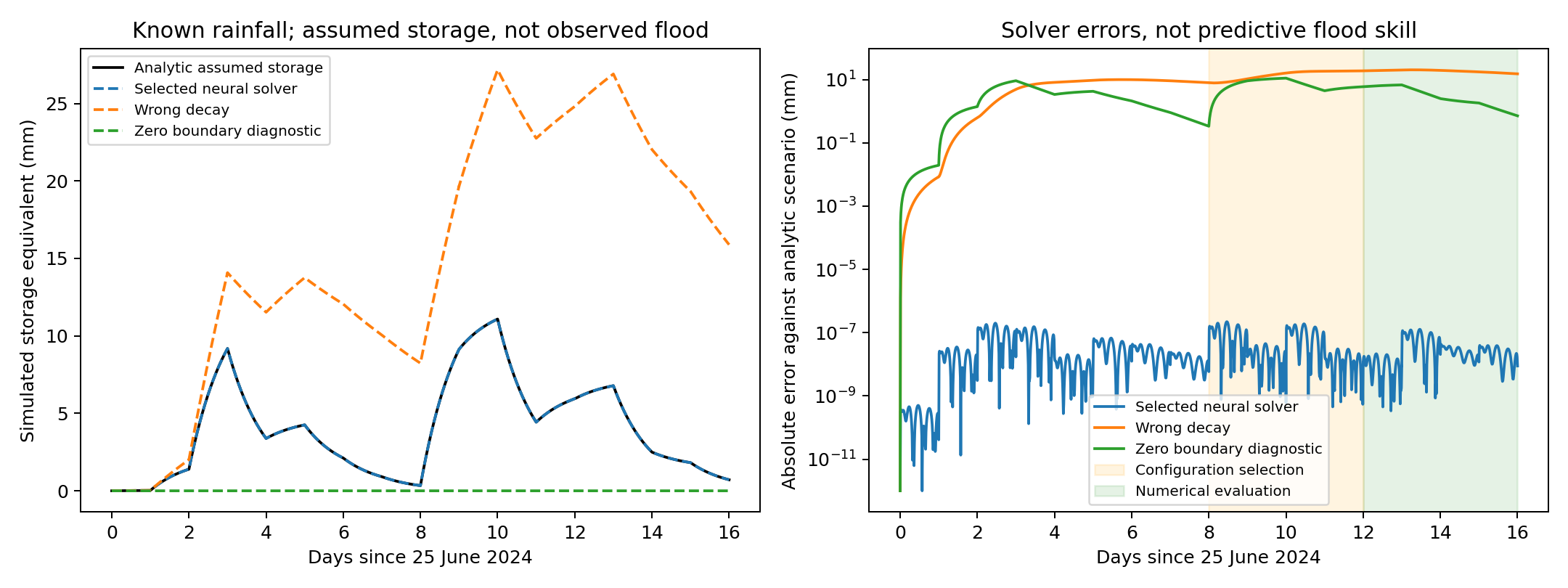
Twelve sets of network settings were tried, each with three different random starting choices. Results from 3–6 July were used to choose settings; results from 7–10 July were checked afterward. The solver still receives each day's known rainfall while calculating that day. This is not a test of predicting unknown future rainfall.
How to read the comparison
The black curve is the exact answer for the assumed container model. The selected neural solver follows it closely. A deliberately wrong drainage setting gives a different answer. The zero-boundary diagnostic stays at zero because it receives no interior equation information and starts empty; it is not a competing model trained on river measurements.
Why there are several error measures
One measure checks distance from the exact answer. Another checks whether the equation is followed. Water-budget checks ask whether water entering, leaving and remaining adds up. A continuity check looks for a jump when one day ends and the next starts. Passing these checks does not replace comparison with measured river flow.
Use the full view for the complete technical discussion, figures, interactive elements and sources.
Adrian Dunkley · Physics-informed numerical verification
Can the solver follow the equation?
Actual Jamaican rainfall inputs, an assumed storage model and independently checked numerical results.
What these results mean
This is a retrospective equation-solver study, not a flood forecast. The rainfall inputs are satellite-plus-gauge estimates. Storage and outflow are simulations: there are zero observed runoff targets. Small numerical errors do not validate the assumed runoff fraction, residence time or flood impacts.
What was compared
Twelve configurations were evaluated across three seeds. Selection chose 16 fixed hidden features, boundary weight 1 and ridge row amplitude 0.000001 (the squared-penalty coefficient is 0.000000000001).
- 25 June–2 July 2024: warm-up history.
- 3–6 July: configuration selection against an analytic storage solution.
- 7–10 July: subsequent numerical evaluation.
Each day's output weights are fitted using that day's known rainfall, including evaluation days. This split evaluates configuration choice, not a causal future forecast. The assumed runoff fraction is 0.3 and residence time is one day.
All-seed evaluation results
Root mean square error measures disagreement with the analytic scenario. The physics residual measures violation of the intended storage equation. Water-budget errors include jumps from the propagated initial state.
| Diagnostic | Seed | Storage error (mm) | Equation residual (mm/day) | Max daily budget error (mm) | Max continuity jump (mm) |
|---|---|---|---|---|---|
| selected physics | 23 | 4.16e-08 | 9.84e-07 | 7.45e-08 | 1.57e-11 |
| selected physics | 37 | 6.25e-08 | 1.24e-06 | 6.7e-08 | 8.48e-11 |
| selected physics | 53 | 1.46e-08 | 3.68e-07 | 2.47e-08 | 1.57e-11 |
| wrong decay | 23 | 18.7 | 17.9 | 20.7 | 1.59e-11 |
| wrong decay | 37 | 18.7 | 17.9 | 20.7 | 7.17e-10 |
| wrong decay | 53 | 18.7 | 17.9 | 20.7 | 1.49e-11 |
| zero boundary diagnostic | 23 | 4.1 | 3.71 | 7.28 | 0 |
| zero boundary diagnostic | 37 | 4.1 | 3.71 | 7.28 | 0 |
| zero boundary diagnostic | 53 | 4.1 | 3.71 | 7.28 | 0 |
Download all-seed results (CSV) · Download configurations and metrics (JSON)
The wrong-decay diagnostic deliberately uses an incorrect parameter. The zero-boundary diagnostic is identically zero, not a data-trained competing model. No runtime or predictive superiority is established.
What would establish flood-prediction skill?
Independent streamflow or stage records, rating curves, subdaily rainfall, channel and drainage geometry, and checked inundation observations are needed. Daily rainfall cannot establish a flash flood's within-day peak or arrival time. A future catchment experiment must evaluate unseen events with equal issue-time information and report peak timing, magnitude, inundation, uncertainty and computational cost.
This short, retrospective search uses one rainfall sequence. Boundary weights are nearly tied; the selected configuration is not a universally optimal network. The protocol is generated by the executable, not a preregistered experiment.
Terms explained
Select a term to read its meaning in this study.
Physics-informed neural network
A neural network fitted partly by checking how well its answer follows a chosen physical equation. A small equation error does not prove the equation describes the real situation.
Manufactured solution
A deliberately chosen mathematical answer used to build a test equation. It allows exact error checks but is not an observed event.
Forcing
An input that drives a model. Rainfall drives the storage calculation; the first mathematical test uses a constructed input instead.
CHIRPS
Climate Hazards Group InfraRed Precipitation with Station data: rainfall estimates combining satellite information and rain-gauge records. They are estimates, not perfect measurements at every point.
Reservoir
Here, a mathematical container that gains water from rainfall and loses stored water at an assumed rate. Each map cell is separate, so water is not routed through a river network.
Residual
The amount by which a calculated answer fails to satisfy the chosen equation. Zero means agreement with that equation, not necessarily agreement with nature.
Root mean square error
A measure of how far answers are from their comparison values, giving more weight to large errors. Here the comparison is a mathematical solution, not measured floodwater.
Seed
A recorded number that makes the network's random starting choices repeatable. Different seeds help check whether a result depends on one lucky starting choice.
Catchment
An area whose rainfall drains toward a shared river or outlet. The selected map cells in this experiment are not a mapped catchment.
Discharge
The volume of water passing a river location per unit of time. The paper's simulated outflow has not been checked against measured river discharge.
Continuity jump
A mismatch between the water storage passed from the previous day and the storage predicted at the start of the next day.
Water budget
An accounting check that water entering minus water leaving matches the change in stored water.
Analytic solution
An answer calculated directly from a mathematical expression. It provides a comparison for the neural solver without proving the model's assumptions are correct.
Surface elevation
The mapped height of the surface, which can include trees and buildings. It is not the same as a survey of the riverbed.
Upwind method
A numerical method that updates a location using information from the side the modelled flow comes from. Here it provides a conventional solver comparison.